




Integrated planning and spatial solutions to support urban and regional development, enhance quality of life, and guide sustainable growth and investment.
Examples of Urban Planning and Master Plan Projects
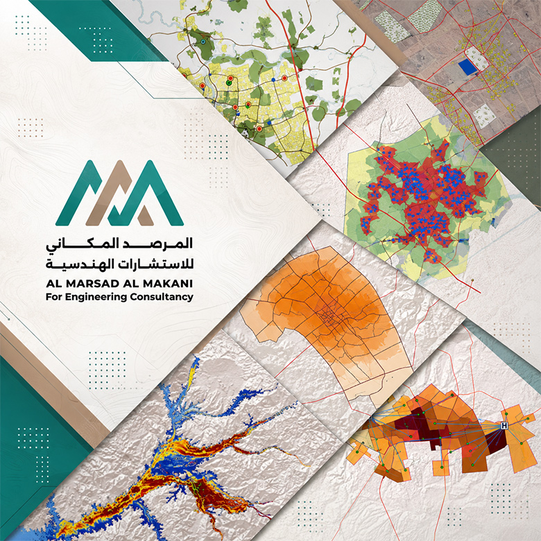
This portfolio features a wide range of urban planning, master planning, and spatial analysis projects carried out by Al Marsad Al Makani across various cities and regions. The projects cover urban and regional development, land use analysis, service distribution, quality-of-life indicators, investment opportunities, urban growth and expansion management, tourism planning, as well as flood risk assessment and its impact on urban areas and infrastructure.
These projects are based on the integration of urban planning with Geographic Information Systems (GIS), remote sensing, geospatial databases, spatial analysis, and hydrological and hydraulic modeling. This integrated approach transforms urban, demographic, economic, and environmental data into maps, indicators, scenarios, and planning recommendations that help identify priorities, guide future development, improve the efficiency of services and infrastructure, and provide relevant authorities and decision-makers with reliable spatial information.
Integrated planning and spatial solutions to support urban and regional development, enhance quality of life, and guide sustainable growth and investment.
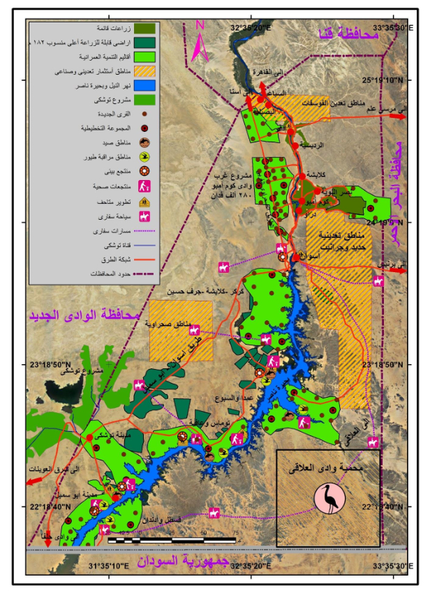
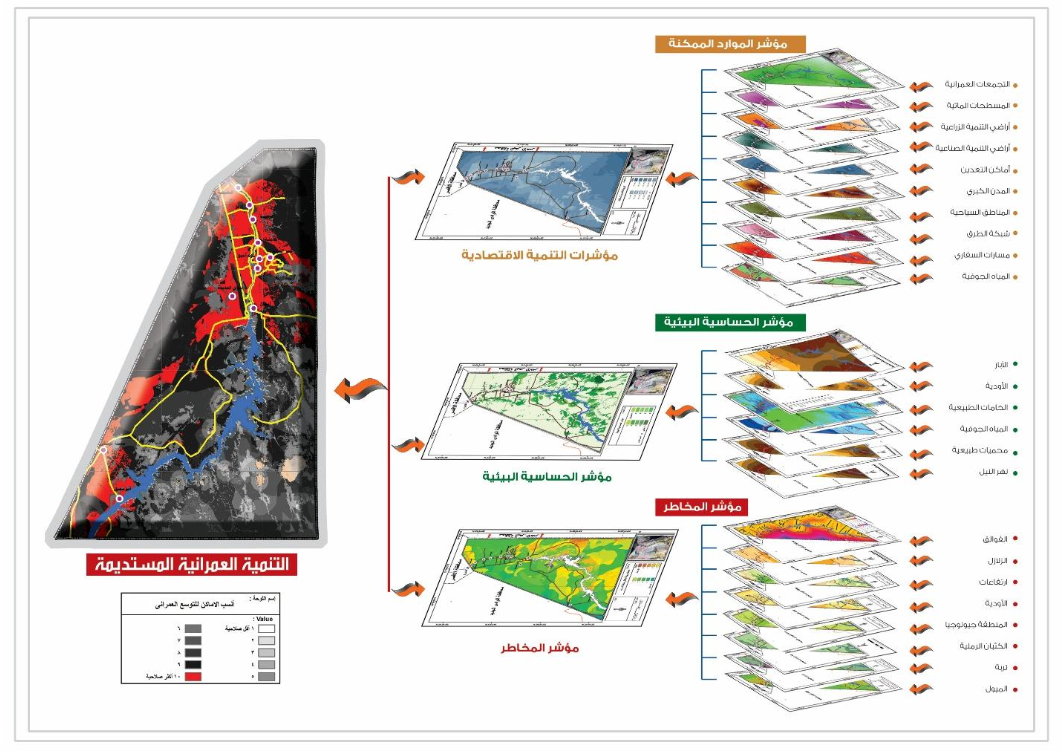
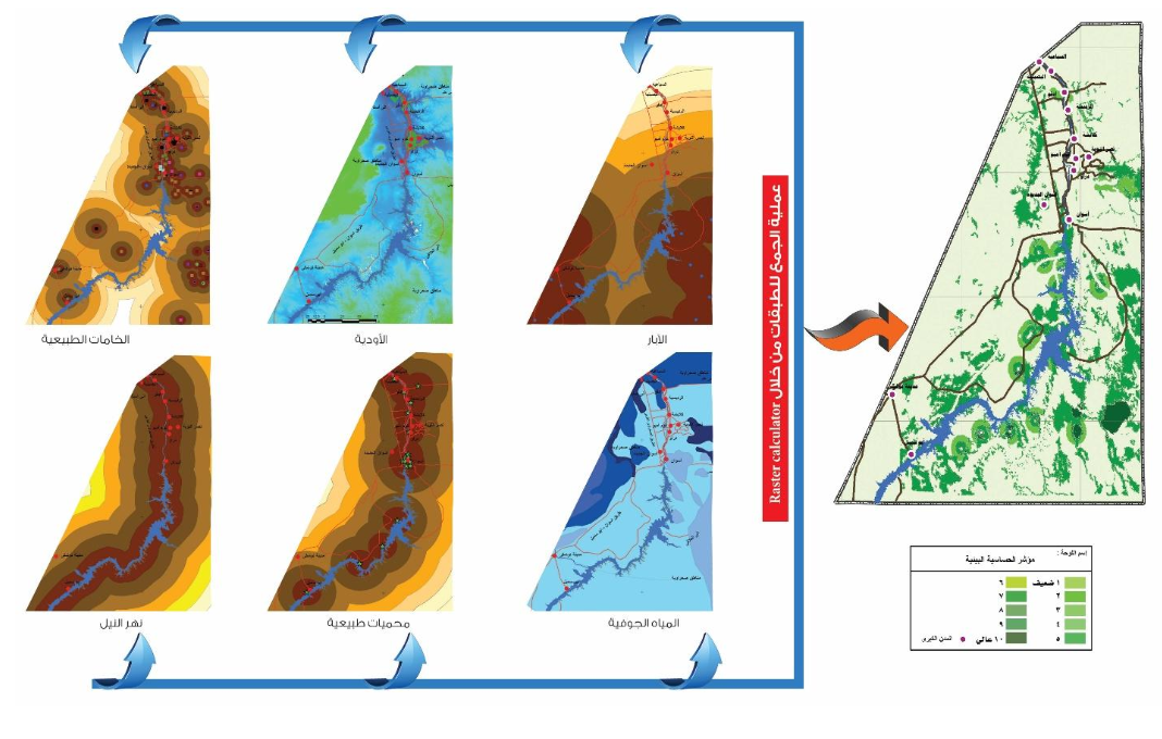
Building and Updating the Investment Opportunities Map for Aswan Governorate
- Project TypeSpatial Planning and Investment Opportunity Analysis
- LocationAswan Governorate – Arab Republic of Egypt
- Key TechnologiesGIS – Geodatabase – MCDA – Accessibility Analysis – Land Suitability Analysis – Dashboards
- Main DeliverablesGIS Dashboards – Investment Opportunity Maps – Geospatial Database – Development Priority Maps – Application
- Project DescriptionAn integrated project to build and update a digital investment opportunities map for Aswan Governorate and analyze spatial development potential, with the objective of identifying priority investment locations and providing a geodatabase and opportunity analysis platform that supports planning, investment attraction, and decision-making. The project was based on collecting and analyzing spatial and economic data, developing a geospatial database and interactive GIS dashboards, and modeling investment potential using Geographic Information Systems. It also included the preparation of urban development indicators, classification and prioritization of investment opportunities, and the development of an application.
Integrated planning and spatial solutions to support urban and regional development, enhance quality of life, and guide sustainable growth and investment.
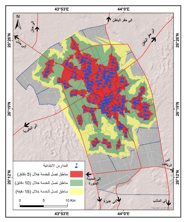
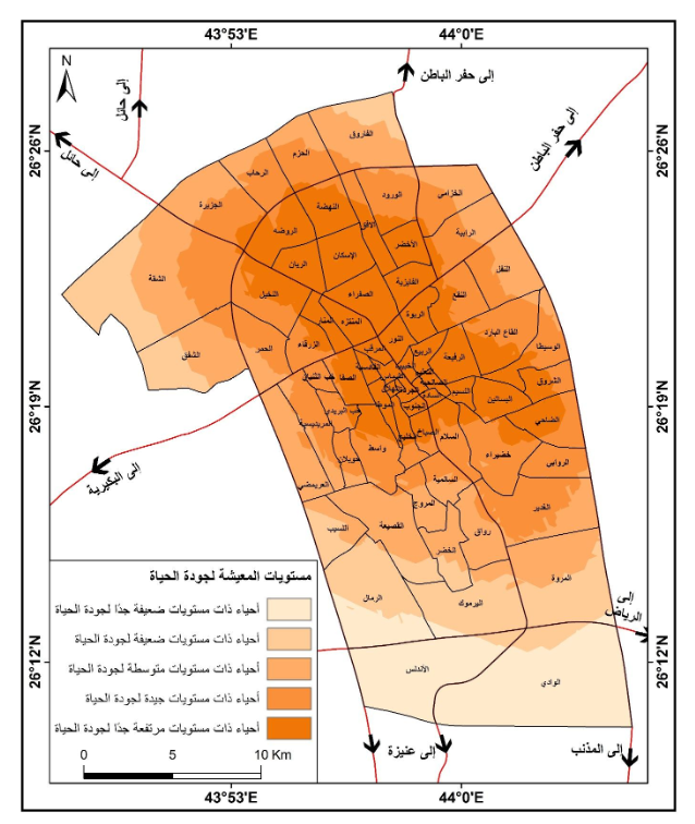
Urban Development and Quality of Life Indicators Map for Buraidah City
- Project TypeUrban Planning and Quality of Life Indicators
- LocationBuraidah City – Kingdom of Saudi Arabia
- Key TechnologiesGIS – Geodatabase – MCDA – Accessibility Analysis – Gap Analysis – Dashboards
- Main DeliverablesUrban Development Maps – Quality of Life Maps – Development Priorities – Geospatial Database – Dashboards
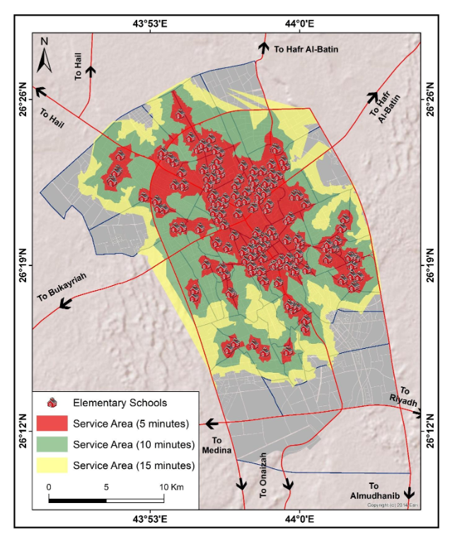
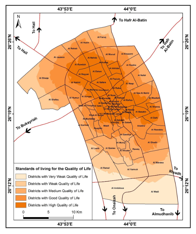
- Project DescriptionA project to measure and analyze urban development and quality of life indicators in Buraidah City and identify urban development priorities, supporting sustainable planning and contributing to the achievement of Saudi Vision 2030 objectives. The methodology included collecting and analyzing spatial and statistical data, developing an integrated geospatial database, calculating urban development and quality of life indicators, conducting spatial analyses, and creating interactive dashboards. The project relied on data related to land use, population distribution and density, public services and utilities, road and transportation networks, green spaces, urban development, infrastructure, and essential services. The studies also included assessing the efficiency of public service distribution, quality of life, and accessibility to services, leading to the classification of development priorities. The project resulted in maps of urban development and quality of life indicators, development priority maps, Multi-Criteria Decision Analysis (MCDA), development gap analysis, an integrated GIS database, interactive dashboards, a dedicated application, and technical reports supporting urban planning and informed decision-making.
Integrated planning and spatial solutions to support urban and regional development, enhance quality of life, and guide sustainable growth and investment.
Sustainable Urban Development and Flood Mapping in Tabuk City
- Project TypeUrban Planning and Flood Risk Studies
- LocationTabuk City – Kingdom of Saudi Arabia
- Key TechnologiesGIS – Remote Sensing – DEM – WMS – HEC-RAS – Change Detection
- Main DeliverablesFlood Risk Maps – Urban Expansion Maps – Development Guidance – Flood Protection Alternatives
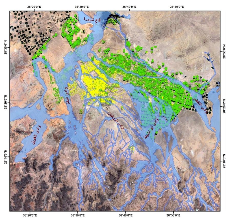
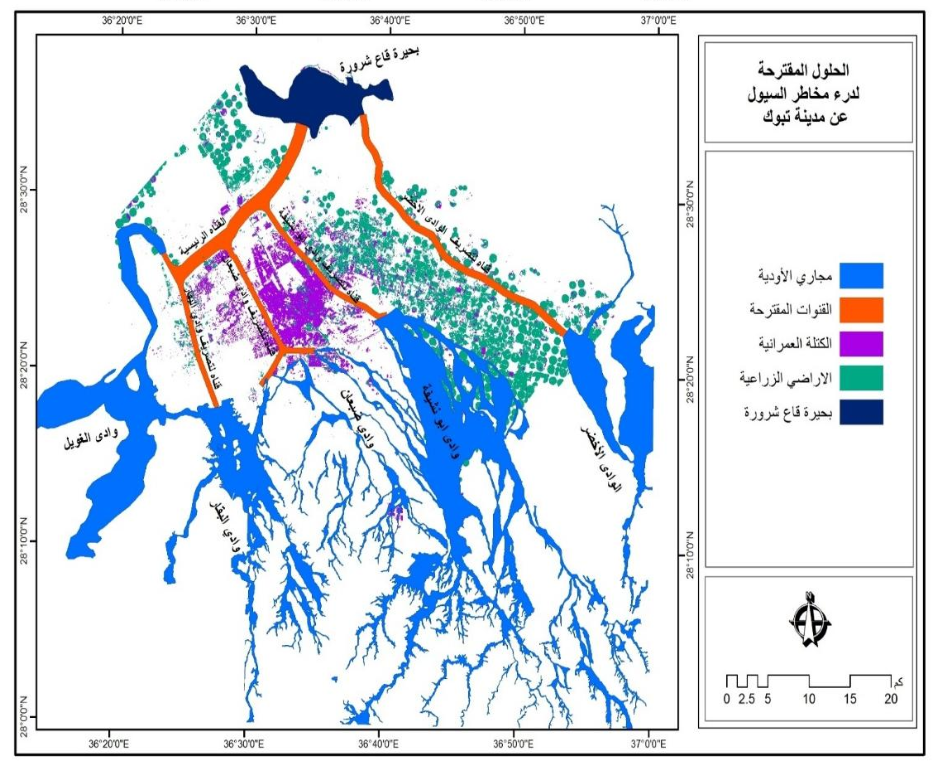
- Project DescriptionA project integrating urban planning with flood risk analysis to identify urban areas exposed to flooding in Tabuk City and guide future development away from high-risk zones. The project also included delineating flood extents and developing appropriate protection alternatives to mitigate flood hazards. The study was based on the collection and analysis of hydrological and spatial data, remote modeling of wadis and drainage basins using satellite imagery and Digital Elevation Models (DEM), and analysis of surface runoff and flood-prone areas using HEC-RAS. It also incorporated GIS-based spatial analysis, topographic maps, rainfall and hydrological data, land use and land cover information, and digital elevation datasets. The analyses included land use and land cover assessment, evaluation of urban growth trends, and modeling of future urban expansion. Hydrological and hydraulic analyses were also integrated with Change Detection techniques to identify changes in urban development and land use. The final outputs included maps of urban change, land use, urban expansion, and hazard zones, as well as a sustainable development guidance map, together with recommendations and solutions to reduce flood risks and improve stormwater management.
Integrated planning and spatial solutions to support urban and regional development, enhance quality of life, and guide sustainable growth and investment.
Flood Risk Assessment for Urban Expansion in Wadi Nu’man Basin
- Project TypeFlood Risk Assessment and Urban Planning Support
- LocationWadi Nu’man – Makkah – Kingdom of Saudi Arabia
- Key TechnologiesHEC-HMS – HEC-RAS 2D – GIS – Remote Sensing – DEM – Risk Matrix
- Main DeliverablesFlood Maps – Water Depths and Velocities – Hazard Zones – Protection Solutions and Measures
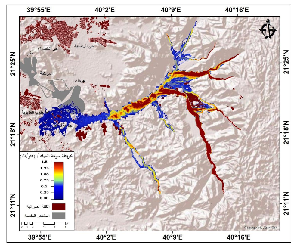
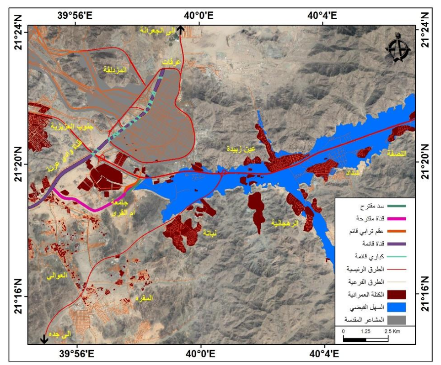
- Project DescriptionA project to assess flood risks affecting urban expansion within the Wadi Nu’man Basin in Makkah and to prepare detailed flood hazard maps and appropriate engineering solutions for protecting urban areas and mitigating flood impacts. The study was based on collecting and analyzing hydrological, topographic, and spatial data, together with urban development networks. HEC-HMS was used to model surface runoff, supported by Digital Elevation Models (DEM) and remote sensing techniques. The study also incorporated rainfall data and digital GIS elevation models to generate and analyze flood hazard maps using two-dimensional HEC-RAS 2D modeling. The analyses included hydrological and hydraulic studies, hazard assessment, geological and soil maps, satellite imagery, land use and land cover (LULC), and spatial analysis. The project resulted in flood hazard maps showing inundation extents, water depths, flow velocities, and directions, as well as identifying urban areas exposed to flood risks. The study also provided engineering solutions and protection measures to reduce flood hazards, in addition to maps, analysis outputs, and technical reports that support informed decision-making.
Integrated planning and spatial solutions to support urban and regional development, enhance quality of life, and guide sustainable growth and investment.
Urban Development and Infrastructure in Wadi Bair Basin – Al Qurayyat
- Project TypeFlood Risk Assessment for Urban Development and Infrastructure
- LocationWadi Bair Basin – Al Qurayyat City – Kingdom of Saudi Arabia
- Key TechnologiesHEC-HMS – HEC-RAS 2D – GIS – Remote Sensing – Flood Hazard Analysis
- Main DeliverablesFlood Maps – Flood Impact on Urban Areas – Protection Priorities – Geospatial Database
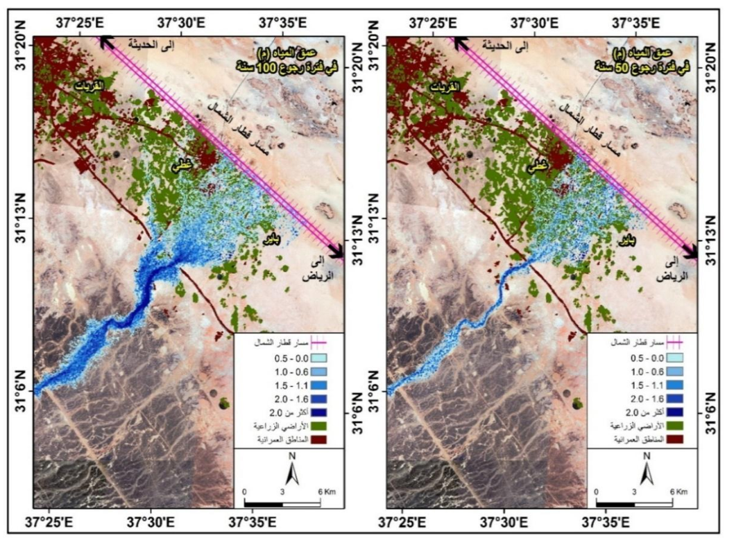
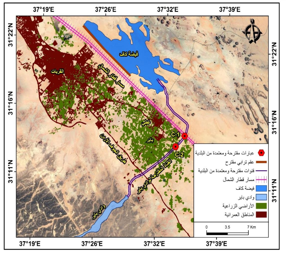
- Project DescriptionA project to assess the impact of flood risks on urban development and infrastructure within the Wadi Bair Basin in Al Qurayyat City, with the objective of identifying hazard-prone areas, analyzing the level of flood impact on built-up areas, transportation networks, and utilities, and proposing appropriate measures to reduce risks and support sustainable development. The study was based on hydrological, topographic, and spatial data, supported by Geographic Information Systems (GIS) and remote sensing. HEC-RAS 2D was used for two-dimensional flood simulation, while HEC-HMS was applied for surface runoff modeling. The project incorporated rainfall data, Digital Elevation Models (DEM), satellite imagery, geological and soil maps, land use and land cover data, as well as transportation and infrastructure network data. Given the impact of flooding on development and infrastructure, a comprehensive Flood Hazard Analysis was conducted, including hydrological and hydraulic analyses to identify flood-prone areas, inundation extents, water depths, flow velocities, and flow directions. The final outputs included flood impact maps, protection priorities and measures, a geospatial database, and technical reports to support planning and decision-making.
Integrated planning and spatial solutions to support urban and regional development, enhance quality of life, and guide sustainable growth and investment.
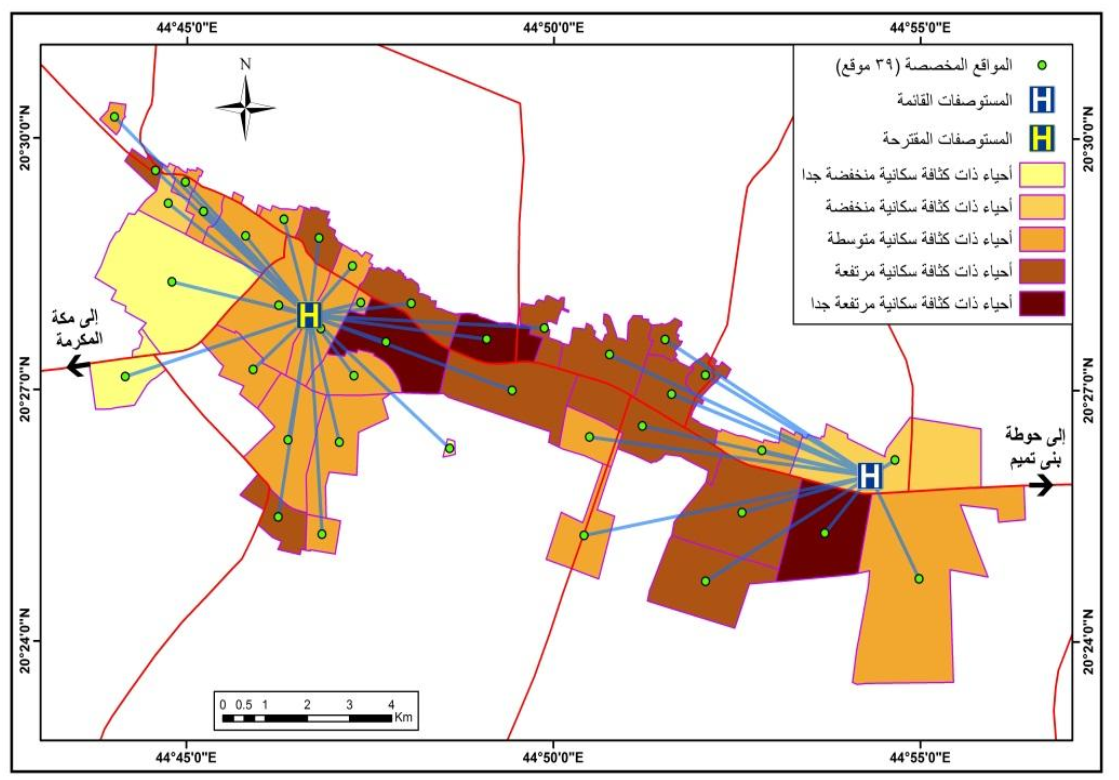
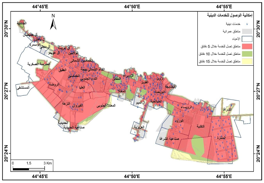
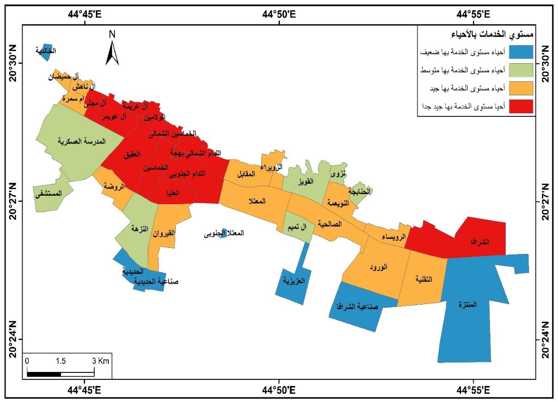
Supporting the Urban Development Map of Wadi Al-Dawasir City
- Project TypeUrban Planning and Service Distribution Analysis
- LocationWadi Al-Dawasir – Kingdom of Saudi Arabia
- Key TechnologiesGIS – Accessibility Analysis – Gap Analysis – MCDA
- Main DeliverablesService Efficiency Maps – Development Needs – Proposed Locations for New Services – Performance Indicators
- Project DescriptionA project aimed at assessing the alignment of public service distribution with urban expansion in Wadi Al-Dawasir City, measuring service efficiency according to urban planning standards, and identifying current and future needs to support sustainable development plans and improve quality of life. The project methodology included studying urban patterns and population distribution, analyzing the efficiency of service distribution, assessing accessibility to services, identifying development priorities and service gaps, and preparing scenarios for service development through 2030 using Geographic Information Systems (GIS). The study relied on urban plans, population distribution, neighborhood boundaries, administrative boundaries, road networks, service locations, land use data, and municipal and planning datasets. It also included analysis of service distribution efficiency and assessment of future needs. The main outputs included service efficiency and development priority maps, accessibility analysis, service gap analysis, Multi-Criteria Decision Analysis (MCDA), assessment of current and future needs, identification of proposed locations for new services, and the preparation of performance indicators, reports, and recommendations to support urban planning and improve quality of life.
Integrated planning and spatial solutions to support urban and regional development, enhance quality of life, and guide sustainable growth and investment.
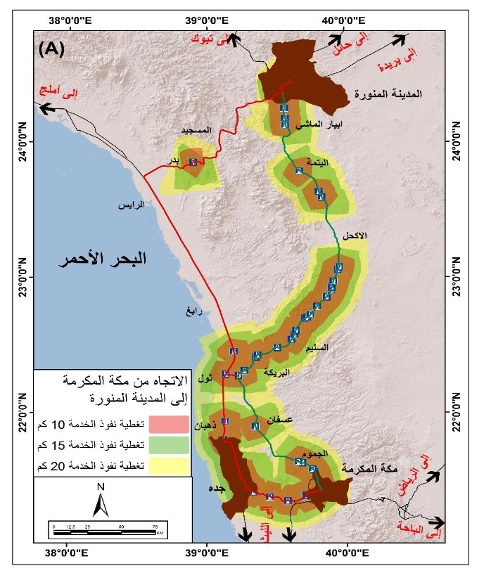
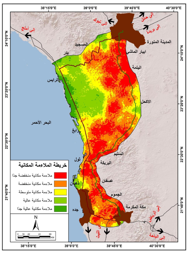
Urban Planning for Fuel Stations and Service Centers Along the Makkah–Madinah Road
- Project TypeRoadside Service Planning and Spatial Analysis
- LocationMakkah–Madinah Road
- Key TechnologiesGIS – Accessibility Analysis – MCDA – Spatial Suitability Analysis
- Main DeliverablesCoverage Maps – Service Gap Areas – Proposed Locations – Service Development Priorities
- Project DescriptionA specialized urban and spatial planning project for fuel stations and service centers along the road connecting Makkah and Madinah. The project aimed to improve the distribution of roadside services, enhance regional infrastructure efficiency, achieve equitable spatial coverage, reduce travel and access times, and identify the most suitable locations for new facilities in support of sustainable development. The methodology included assessing the existing distribution of fuel stations and service centers, analyzing traffic movement and demand patterns, evaluating service coverage and identifying underserved areas, and assessing site suitability based on urban, environmental, and economic criteria. The project also included the preparation of scenarios to address future service needs. The study relied on road network data, existing service locations, urban plans, land use information, and environmental, economic, and planning datasets. The final outputs included a map of development priorities, analysis of current and future needs, proposed locations for new facilities, performance indicators, and development plans that contribute to achieving a balance between service quality and road safety.
Integrated planning and spatial solutions to support urban and regional development, enhance quality of life, and guide sustainable growth and investment.
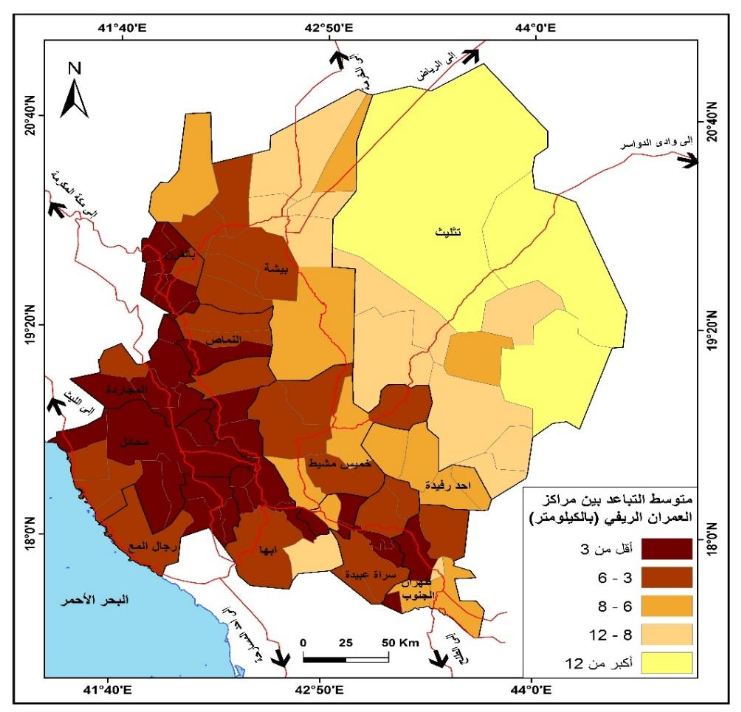
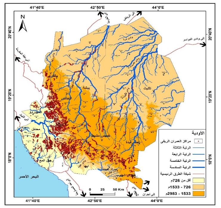
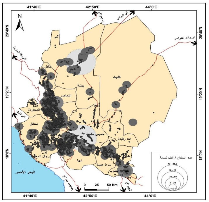
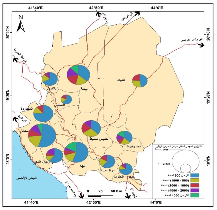
Regional Planning for Rural Settlements in the Asir Region
- Project TypeRegional Planning and Rural Settlement Development
- LocationAsir Region – Kingdom of Saudi Arabia
- Key TechnologiesGIS – Spatial Density Analysis – Regional Planning Analysis
- Main DeliverablesRural Settlement Maps – Density and Distribution Analysis – Development Priorities – Regional Planning Indicators
- Project DescriptionA project to assess the spatial distribution of rural settlements across the Asir Region and support urban and regional development according to the spatial characteristics of each area, while identifying development and service priorities and enhancing planning efficiency in line with sustainable development principles. The study included analysis of the rural settlement structure, geographic distribution, population densities, and the influence of natural and human factors on development, as well as the identification of spatial priorities and preparation of maps and indicators supporting regional planning. The project relied on data related to urban settlements, population, administrative boundaries, terrain, road networks, land use, and planning datasets. The analyses covered settlement distribution patterns, spatial density, distances between settlements, natural and human factors, and regional development priorities. The study resulted in maps of rural settlements, density and spatial distribution, development priority maps, and regional planning indicators, in addition to recommendations and technical reports aimed at promoting sustainable development and supporting decision-makers.
Integrated planning and spatial solutions to support urban and regional development, enhance quality of life, and guide sustainable growth and investment.
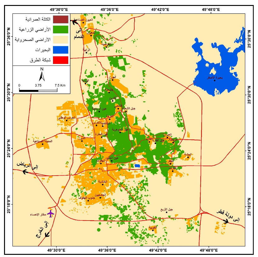
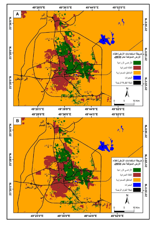
Future Land Use Planning in Al-Ahsa Oasis
- Project TypeLand Use Planning and Future Growth
- LocationAl-Ahsa Oasis – Kingdom of Saudi Arabia
- Key TechnologiesGIS – Remote Sensing – Change Analysis – Urban Suitability Analysis
- Main DeliverablesFuture Growth Maps – Land Use Maps – Development Priorities – Urban Expansion Scenarios
- Project DescriptionA project to study urban development in Al-Ahsa Oasis and analyze the impact of urban expansion on agricultural land and natural resources, with the aim of developing future urban development scenarios that support sustainable urban growth, approved planning frameworks, and the objectives of Saudi Vision 2030. The project relied on analyzing land use changes over different time periods, studying growth patterns and the factors influencing them, and identifying suitable areas for future urban expansion through spatial modeling and suitability analysis. The study also included analyzing urban plans, existing land uses, road networks, population data, development projects, and environmental and agricultural factors affecting urban growth. The outputs included maps of current and future growth, future land use scenarios, development priorities, areas suitable for urban expansion, and assessment of the impact of development on agricultural land and natural resources. The project also delivered sustainable urban development indicators and technical reports to support planning and informed decision-making.
Integrated planning and spatial solutions to support urban and regional development, enhance quality of life, and guide sustainable growth and investment.
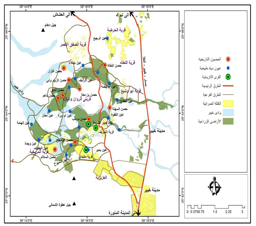
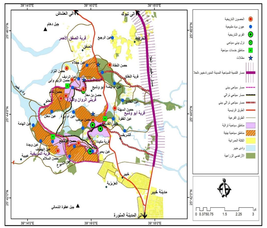
Sustainable Tourism Development Plan for Khaybar City
- Project TypeSustainable Tourism Planning and Development
- LocationKhaybar City – Kingdom of Saudi Arabia
- Key AreasTourism – Investment – Heritage – Environment – Infrastructure
- Main DeliverablesTourism Development Plan – Investment Opportunities – Priority Maps – Implementation Phases and Cost
- Project DescriptionA project to prepare an integrated sustainable tourism development plan for Khaybar City, aimed at maximizing the value of its natural, heritage, and cultural assets, supporting tourism investment, improving the quality of infrastructure and services, and contributing to economic development in alignment with the objectives of Saudi Vision 2030. The study included evaluating natural, cultural, and heritage tourism assets, analyzing the condition of tourism infrastructure and services, identifying investment opportunities and potential projects, and preparing an implementation plan and development priorities for tourism investments. The study relied on data related to archaeological and heritage sites, natural assets, urban plans, road networks, land use, population and investment data. The final outputs included a comprehensive tourism development plan, a map of proposed tourism projects, development priorities, implementation phases, performance indicators, investment opportunities, and technical reports supporting tourism planning and sustainable development.
Integrated planning and spatial solutions to support urban and regional development, enhance quality of life, and guide sustainable growth and investment.
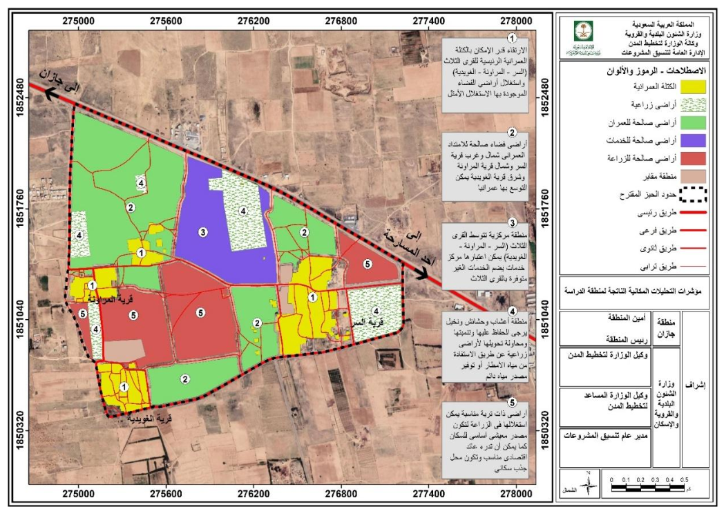
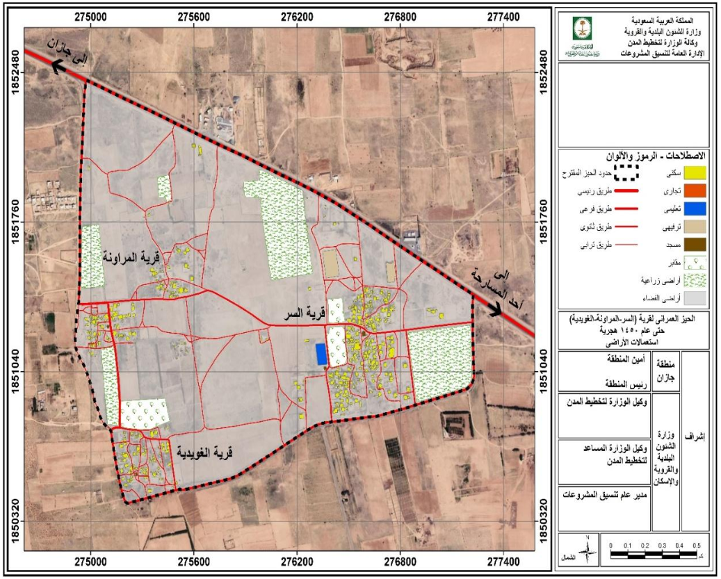
Urban Growth Boundaries and Development Plans for Residential Settlements in Ahad Al Masarihah Governorate
- Project TypeUrban Planning and Preparation of Urban Growth Boundaries
- LocationAhad Al Masarihah Governorate – Kingdom of Saudi Arabia
- Key AreasUrban Growth – Land Use – Residential Settlements – Local Plans
- Main DeliverablesUrban Growth Boundary Plans – Development Maps – Expansion Priorities – Planning Recommendations
- Project DescriptionA project to prepare urban growth boundaries for villages and residential settlements in Ahad Al Masarihah Governorate, aimed at regulating urban growth, improving land-use efficiency, supporting local and regional plans, and promoting sustainable development in accordance with approved planning regulations and standards. The scope included studying existing urban conditions, growth and expansion patterns, identifying current and future expansion requirements, and preparing proposals for urban growth boundaries and development zones based on the spatial characteristics of the project area. The study relied on urban plans, land use data, road networks, population data, site information, administrative boundaries, and other supporting datasets. The analyses also covered urban growth patterns, land use, expansion requirements, connectivity between settlements, and the efficiency of development distribution. The final outputs included urban growth boundary plans, development maps, future expansion priorities, growth indicators, technical reports, and planning recommendations supporting the preparation and approval of local plans.
Integrated planning and spatial solutions to support urban and regional development, enhance quality of life, and guide sustainable growth and investment.
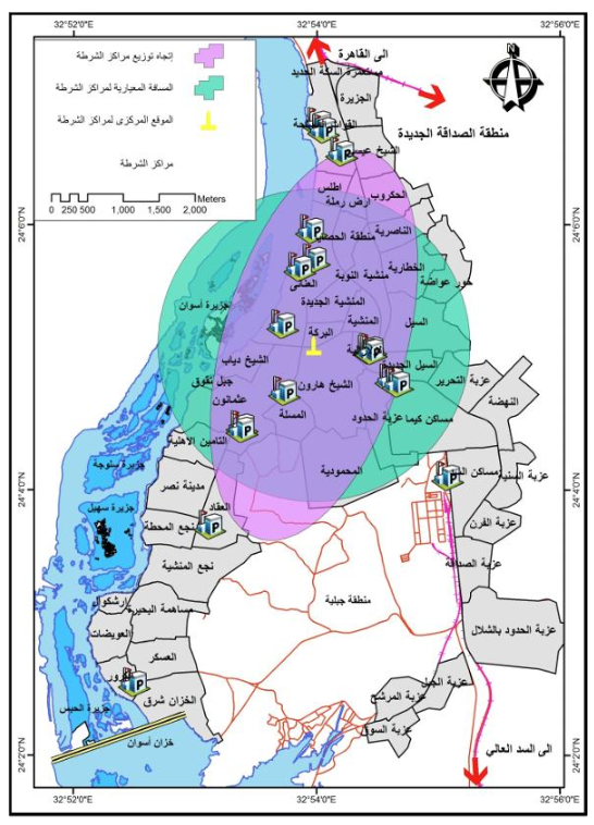
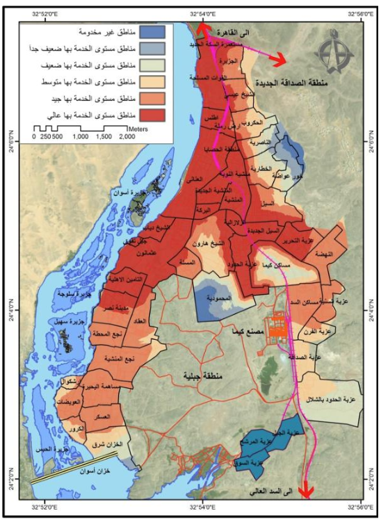
Urban Development and Improving Service Distribution in Aswan City
- Project TypeUrban Planning and Service Distribution Analysis
- LocationAswan City – Arab Republic of Egypt
- Key AreasUrban Growth – Public Services – Quality of Life – Investment Priorities
- Main DeliverablesService Maps – Development Priorities – Efficiency Indicators – Service Distribution Improvement Plan
- Project DescriptionA project to assess the efficiency of public service distribution and its relationship with urban growth in Aswan City, identify areas suffering from service shortages and development needs, support the preparation of development plans, improve quality of life, and enhance investment efficiency in line with sustainable development principles.
Integrated planning and spatial solutions to support urban and regional development, enhance quality of life, and guide sustainable growth and investment.
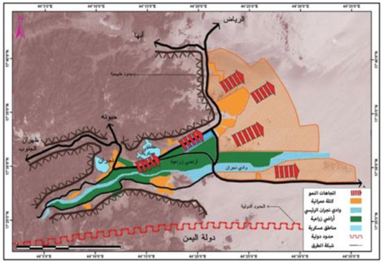
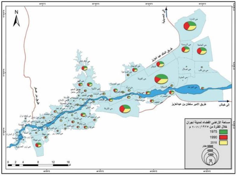
Urban Expansion and Land Use Management in Najran City
- Project TypeUrban Planning and Land Use Management
- LocationNajran City – Kingdom of Saudi Arabia
- Key TechnologiesGIS – Remote Sensing – Land Use Change Analysis – Urban Growth Analysis
- Main DeliverablesUrban Expansion Maps – Land Use Maps – Development Priorities – Future Growth Scenarios
- Project DescriptionA project to assess urban expansion patterns in Najran City and analyze land use changes and their impact on urban development, with the objective of supporting planning processes, improving land-use efficiency, and promoting sustainable urban development in alignment with the objectives of Saudi Vision 2030. The project was based on studying urban development over different time periods, analyzing land use patterns and urban expansion, assessing the impact of growth on agricultural land and natural resources, and identifying suitable areas and priorities for future development. The study utilized urban plans, land use data, road networks, administrative boundaries, population data, satellite imagery, natural environment data, and GIS technologies. The final outputs included urban expansion and land use maps, development priorities, growth and land-use efficiency indicators, urban development and expansion scenarios, and technical reports supporting planning and informed decision-making.